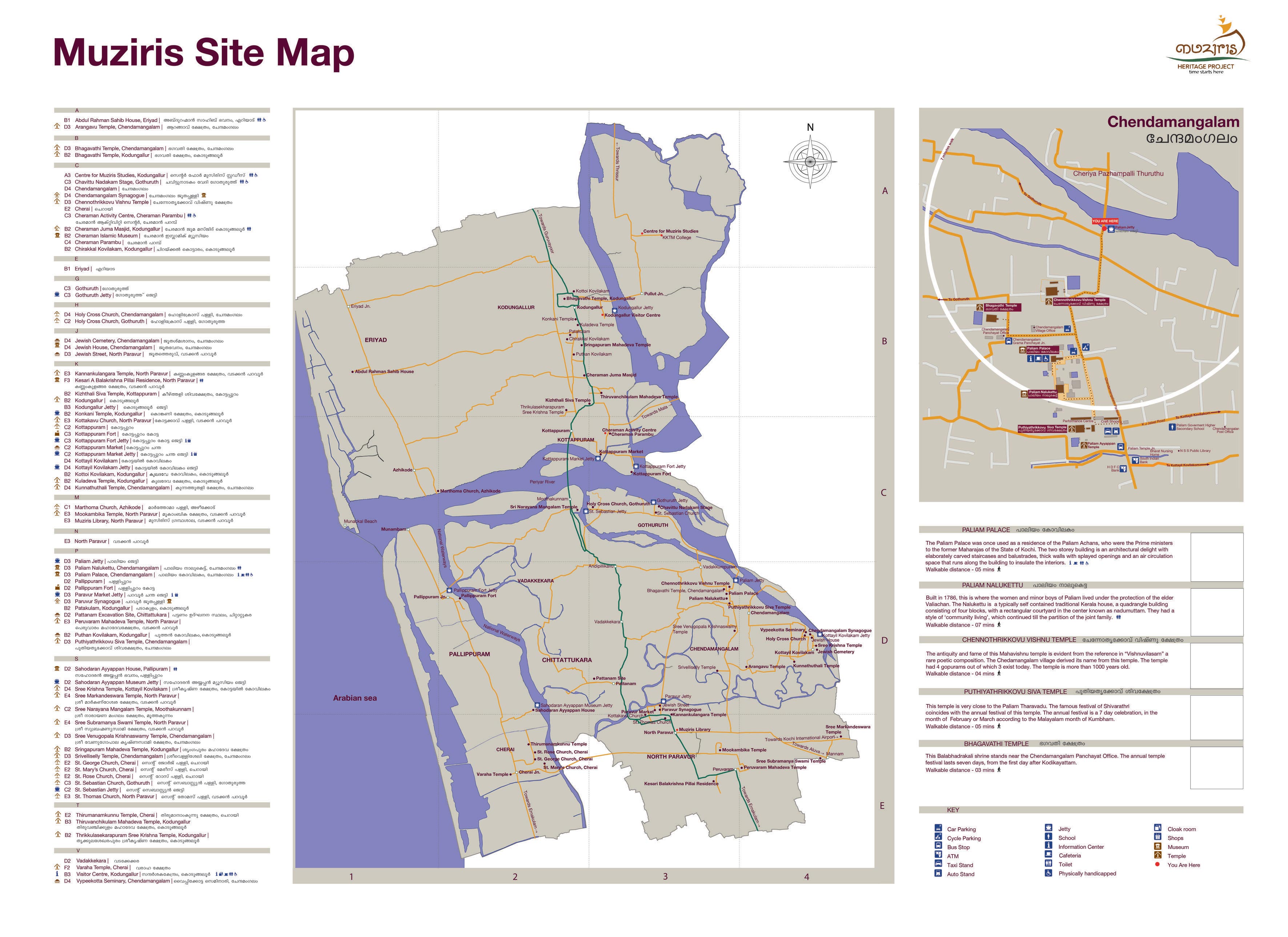
Muziris Heritage Project (MHP) is the first green project of Govt. of Kerala and the largest heritage project in India. Muziris heritage project, now a major tourism venture, stretches between North Paravoor in the Ernakulam district and Kodungalloor in the Thrissur district.
Muziris's history goes possibly 3,000 years back. In ancient time it was one of the major urban settlement and port city. Connected by both land and water, peoples came here in ships and other carriers from various places, cities many parts of the world. Assyria, Babylonia, China, Egypt, Greece, Rome, Arabia, Phoenicia etc were all coming here. Mentioning of this port city has found in Myth, old literature and travelogues of various. Depiction of this old town found in Ramayana, King Asoka's Rock Edicts, famous old Tamil poems (such as Chilappathikaram), etc. In ancient time Muziris known as Murachipattanam. In Ramayana, Murachipattanam is the place where Sugreeva's (one of the Monkey King) sleuths scurried through while looking for the abducted Sita. Roman ships coming to Muziris or Muciri Pattinam laden with gold to be exchanged for pepper found in Sangam literature (such as Agananooru (Akanaṉūṟu)). History says that the capital of the Chera dynasty (Mahodayapuram - Kodungallur) was near to Muziris port. Chola dynasty who were the mightiest ruler of both land and sea, expanded their influence to this western (Arabian sea) sea port. Sometime, Pandyan dynasty wages war against Cheras and claimed victory over them and held the control of this port city for a while. As the history of South India, mainly tied to these three kingdoms. This proves that the Chera Chola and Pandyan kingdom flourished on the shore of River Periyaar, Kaveri and the River Vaighai, respectively.
For Greeks, Romans, Egyptian, Babylonian Muziris was a spice city (mainly pepper). Along with six other major seaports in ancient times, Muziris also marked its place in the ancient sea routes.
But this ancient port had forgotten and dropped off from its importance and erased from the map. The main cause was a big flood on the Periyar River, which wiped out the entire port (Pattanam) and major part of the city in 1341 AD. But, Europeans used later in this area (Muziris). Initially, Portuguese occupied this place, built a fort to control the Arabian sea route to this spice city. As it plays a major strategic point, later Dutch occupied it from Portuguese. During Mysore invasion, Tipu Sultan destroyed the port and now remains only a very few parts of it. British seized from Tipu sultan and later handed over to Travancore. This fort is called the Kottappuram-fort.
Many artifacts of interest unearthed at various sites in the North Paravur-Kodungallur region, through excavations, as part of the Muziris Heritage Project. Agricultural tools, clothes, utensils, coins and inscriptions on plates or papyrus, along with folklore, tell about the lives of the people of that time.Muziris heritage includes two archaeological sites (undertook by KCHR and ASI), Pattanam and fort at Kottappuram. Pattanam, which is in North-Paravoor, the Kerala Council for Historical Research (KCHR), has undertaken a massive research project here. Places and findings in the Muziris project give over 2000 years of Kerala history.
One can cover most of the places mentioned in the Muziris heritage project in a day. Both land and water services are available and there is hop-on hop-off water taxi, boat tour service available to circuit the places. One can visit the fort at Kottappuram, Kottappuram market, Thiruvanchikkulam temple, Cheraman parampu, Cheraman Juma Masjid, which are adjacent places, in a brief walk.

 |
 |
 |
 |
Kottappuram-fort, Kottappuram market both at the mouth of the River Periyar. The Kottappuram fort, also known as Kodungallur-fort, in the old days it was called Cranganore-fort. Portuguese built fort at Kottappuram in 1503. In 1663 Dutch seized the control and in 18th century Travancore bought it from Dutch. But during the Mysore invasion, Tipu Sultan destroyed the fort. Now only some walls and bastion available. Excavation from this site yields a fossilized tree and revealed a complete human skeleton, which gives distinction to Muziris excavations.


ചുവർചിത്രങ്ങൾ, കോട്ടപ്പുറം ചന്ത


പെരിയാർ, കോട്ടപ്പുറംകോട്ട
Here, in this post, included a tiny portion of Muziris heritage. And, below are the interesting highlights of Muziris:
- Pattanam excavation
- Kottappuram Market
- Kottappuram-fort
- Pallippuram-fort
- Gothuruthu Performance & Chavittu Nadakam Centre
- Cheraman Parambu
- Paravur Market
- Harmony Park (Jewish Cemetery)
- The Holy Cross Church
- Marthoma Church, Azhikode
- The Azheekal Sree Varaha Temple
- The Manjumatha Church
- The Kottakavu Church
- Kodungallur Bhagavathy Temple
- Kizhthali Siva Temple
- Thiruvanchikulam Mahadeva Temple
- Cheraman Juma Masjid
- Vypeekotta Seminary
Source: Traveling, Books, Internet, People